gTHIRA
A low cost, non-binding, secured, web-based solution that will give you the capabilities to analyze threats, hazards, and the inherent dangers about a geographical location. Data and information comes from static sources (databases) and dynamic entries (traditional news sources, social media…) contextual to the area of interest. This enterprise wide solution is a mash-up platform that gives the end user a tool (charts and graphs) to analyze threats and hazards from around the world.
| System Capabilities | Key Benefits |
| Aggregates open source data from over 50,000 news services and retrieves 2 million live sensors (weather, flood, tide, stream, seismic…). | Builds awareness (worldwide/area wide) as it relates to the safety, security and protection of people, personnel and investments. |
| Data is analyzed, filtered, categorized for the type of threat and geographically placed on to an electronic map. | A single source destination for information critical to your analysis of the potential dangers of threats and hazards. |
| Data compilation is focused upon 51 threats and hazards then viewed for potential interdependencies to the 18 critical infrastructure sectors. | Enables the ability to pre-plan, educate, train, brief, debrief and mitigate real-world threats and hazards as it relates to the area of interest. |
| Contains over 7 million data knowledge points about the area of interest (i.e. hospitals, terrain, water features, access routes, police, fire…). | Easy to use dashboard that allows you to visit any area of interest and geographically visualize relevant information by layers. |
| An intelligent dictionary is built into the system, constantly searching for “key phrased activities” and geographically placed onto the map. | A discriminating factor for any industry when writing proposals, grants or justification of resources. |
| Thousands of news sources (CNN, BBC, CDC..) are interrogated and its information dynamically displayed for 2 days, unless the area of interest is selected, then it would be for 7 days. | Improves upon existing plans (evacuation, emergency, vulnerability, business resiliency…) and programs (business intelligence, safety, security…) through constant research and collection. |
| System tallies the various threat/hazard, then displays the results on to a chart for a quick determination of the level of threat posed. | Personal Notification System helps to find keywords and phrases within the filtered threats and hazards. |
| Quickly turn on/off any of the threat/hazard events and only those selected incidents will appear, exposing clusters, patterns and trends. | Web-based, password protected, that requires only the use of an internet browser to view and analyze information. |
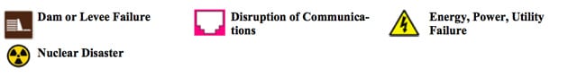
All Threats and Hazards
The analysis of threats and hazards are no longer a challenging endeavor. The cornerstone of a risk analysis / vulnerability assessment / business resiliency program is to establish the threats and hazards that are inherent to the area of interest. The gTHIRA helps to identify 51 threat hazards, displaying significant news events, then geo-locating it on an electronic map (Geographic Information System). The data is constantly streamed into the system; categorized, analyzed and its information interrogated for relevancy.
Naturally Occurring Hazards
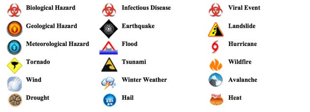
Human Caused Events
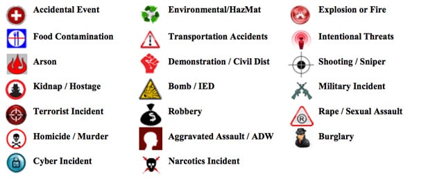
Technological Caused Events
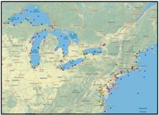
Newsworthy events are constantly updated and displayed on the electronic mapping sys- tem for two (2) days. By placing the Area of Interest indicator at a particular location, the system will reach back into its database and deliver seven (7) days of historical data. A proprietary process of artificial intelligence and human analysis further analyzes each threat event, keeping track of the number of occurrences, and geographically positioning the location. The frequency of historical occurrences can be studied for probabilistic predictions, trending and forecasting through many views; such as date, time, geospatial (terrain) queries of location and types of threat events (i.e., The frequency of robberies as it relates to any of the 18 sectors; industry most likely to be targeted).
Natural Hazards—Sensors and Warnings
| Weather Watches/Warnings GTS contains all of the current weather watches and warnings issued by NOAA’s National Weather Service (NWS). Feeds actively come in 15-60 minute intervals.Stream Floods Stream stations from the USGS provides for 1.5 million sensors to help gauge water data from major rivers, lakes, wells, springs and reservoirs. |
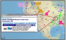 |
| Stream Gages Provides access to the water-resources data collected at 1.5 million sites in all 50 States, in Real-Time Water Data for the Nation. Surface-water data, such as gage height (stage) and stream flow (discharge), are collected at major rivers, lakes, and reservoirs. Ground-water data, such as water level, are collected at wells and springs. |
 |
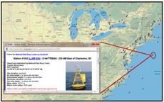
| Tide Stations The Tide Stations layer in GTS contains the locations for all of the various monitoring and observation stations from NOAA’s National Data Buoy Center. Each of these stations provides GTS user with direct access to the current conditions that can include current wind data and wave height. |
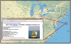 |
| National Data Buoy Center This database holds wind, wave, and other marine data collected by the NOAA National Data Buoy Center (NDBC). The data are collected from NDBC moored buoys and from C-MAN (Coastal-Marine Automated Network) stations located on piers, offshore towers, lighthouses, and beaches. Parameters reported by both buoys and C-MAN stations include air temperature and pressure, wind speed and direction, wind gust, and sea surface temperature. |
 |
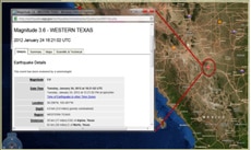
| US Geological Survey Provides GTS with the latest of natural occurring hazards as they occur. The USGS contains four major science disciplines; biology, geography, geology and hydrology that conducts fact finding research with no regulatory responsibility. Raw data and links to active events (hurricane, earthquakes, flood…) are captured and displayed. |
 |
Resources and Databases Used
gTHIRA keeps a professional staff of former police investigators, imagery & information analysts’, statisticians, GIS engineer developers that collect open source data into meaningful information. We’re focused on data acquisition for the purposes of geographic intelligence and aggressor behavior patterning. Pertinent databases are created for the sole purpose of public safety, infrastructure security, and awareness programs. Some databases and resources used may include:
| Various Geological Survey Groups | U.S. Department of Homeland Security |
| United State Geographical Surveys | Energy Information Industries |
| Department of Defense | Environmental Protection Agency |
| Economic Research Services | Organizations that Monitor Health |
| Intelligence Communities | National Oceanic and Atmospheric Orgs |
Have Questions?
 Get in contact with us. We are here to answer any of your security services questions.